Generative Engine Optimisation
OpenGEO
An open specification for publishing canonical organisational meaning and context to intelligent systems.
OpenGEO is about AI interpretation, not geolocation, maps, or geographic data.
Play the GEO Gamble
One die asks why. The other shows how. OpenGEO lets the publisher declare the meaning before AI answers.
Who represents your organisation to AI? Without a direct declaration, intelligent systems reconstruct it from fragments.
The publisher declares the meaning. Publish organisational meaning and context before AI reconstructs them from third-party fragments.
AI systems are interpreting organisations.
Answers about products, services, policies, advice, offers, locations, and media are often reconstructed from search results, cached pages, third-party summaries, feeds, and screenshots. Meaning, tone, canonical media, relationships, and freshness can drift in that reconstruction. OpenGEO gives publishers a direct declaration layer for the meaning and context they know best.
Who OpenGEO is for
OpenGEO is for people responsible for how an organisation is represented, understood, and trusted by AI systems.
In OpenGEO, a publisher is any organisation that publishes information about itself or its resources. This includes businesses, retailers, healthcare providers, public bodies, charities, institutions, and digital services, not only media publishers.
OpenGEO is also intended for the architects, engineers, content and product teams, governance owners, assessors, and AI-system developers who publish, maintain, evaluate, or consume those declarations.
DSCE with Assurance Oversight
DSCE, pronounced "dice", describes how intelligent systems locate, understand, contextualise, and act upon publisher-controlled information. OpenGEO primarily standardises declarations across Discovery, Semantic, and Context. Execution is informed by those declarations but remains outside the specification.
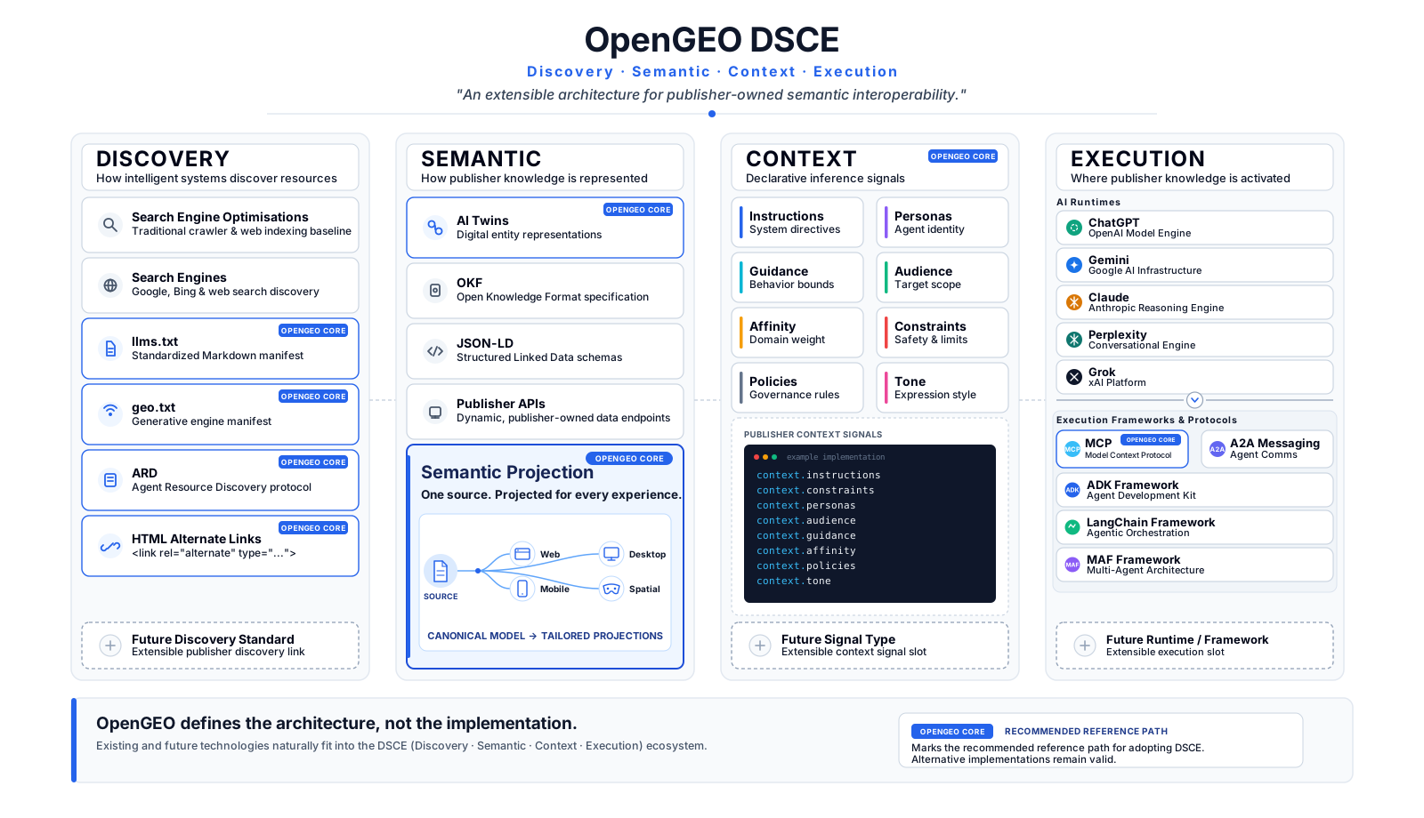
Select any checkpoint card to see who owns it. Select it again to return to the model.
QuestionWhere is the representation, and can this engine find it through a mechanism it supports?
OpenGEO answerExpose the declaration through supported discovery mechanisms and assess which engines can reach it.
QuestionWhat is this resource, which facts are declared, and how does it relate to other resources?
OpenGEO answerThe publisher declares canonical identity, meaning, media, provenance, and resource relationships.
QuestionHow should the resource be understood, including intent, tone, sensitivity, and guidance?
OpenGEO answerThe publisher declares the interpretation envelope it knows better than the execution surface.
QuestionWhat does the consuming system actually do through reasoning, retrieval, rendering, tools, or action?
OpenGEO answerThe consuming system remains responsible for behaviour, informed by the publisher's declarations.
Authority, provenance, freshness, equivalence, consistency, completeness, ownership, security, and auditability across every checkpoint.
The publisher-execution boundary
OpenGEO defines what the publisher knows better than the execution surface. Publishers know their identity, canonical facts and media, resource relationships, intended context, and sources of truth. Consuming systems remain responsible for ranking, reasoning, verification, safety, policy, rendering, and action.
One semantic model. Projections for different needs.
Human-facing HTML and machine-facing forms should be generated from the publisher's source of truth and preserve the same material meaning. The syntax can change without changing the semantic contract.
HTML presents the resource for people, including the organisation's content, journeys, media, and interactions.
A publisher-defined bounded representation may remove irrelevant information or include selected related content for a particular inference or experience while preserving canonical meaning, identity, and provenance.
A Semantic Projection may be delivered to intelligent systems as a Markdown and YAML Semantic Twin, JSON, an API or MCP response, or another machine-facing representation of the shared semantic model.
Context architecture
The context.* namespace lets publishers declare the interpretation envelope around a resource: intent, tone, sensitivity, guidance, provenance, volatility, persona, instructions, or domain-specific context. In the Markdown reference representation it is expressed as nested YAML. A support or sensitive-care journey should not be interpreted like an ordinary commercial journey. Context can configure a shared execution surface for the resource without becoming a prompt format, runtime policy override, or guarantee of behaviour.
This page publishes its own context declarations. Inspect them in the OpenGEO Semantic Twin.
Compatible discovery, independent execution
OpenGEO does not require a single discovery mechanism. HTML alternate links, geo.txt, llms.txt, ARD, NLWeb, MCP discovery, well-known resources, registries, APIs, and future mechanisms may expose or point to OpenGEO resources. Support is engine-relative, so assessment asks which engines can see which layer. Any subsequent reasoning, response generation, tool use, or action remains the responsibility of the consuming system.
An alternate link can identify a page-level Semantic Twin. A conforming OpenGEO site publishes /.well-known/geo.txt to declare site-wide participation, discovery roots, and defaults; individual Twins remain independently interpretable.
Jeremy Howard and Answer.AI's proposal provides a curated root-level orientation file that can direct language models towards important resources and OpenGEO declarations. Claude and Perplexity honour llms.txt as a discovery and orientation mechanism.
Developed by an open working group with participants including Google, Microsoft, and others, ARD can provide agentic resource discovery while pointing to OpenGEO representations.
Developed by Microsoft as an open project, NLWeb provides a model-agnostic path for discovering and interacting with site knowledge through natural-language and MCP-compatible endpoints.
Assurance across every checkpoint
OpenGEO declarations are governance-relevant artefacts. Assurance considers authority, provenance, freshness, cross-surface material equivalence, consistency, completeness, ownership, security, review, and auditability. These vectors expose evidence around publisher-declared truth; they do not certify objective truth. Assurance is not a fifth DSCE layer, and OpenGEO does not claim to provide a complete governance, compliance, authentication, or security framework.
OpenGEO does not prescribe job titles. Context Architecture and semantic publishing may be individual roles or distributed organisational functions. The interactive DSCE model above connects each checkpoint directly to its executive and operational accountability.
OpenGEO is
- An open specification for semantic and contextual declarations
- Publisher-owned and resource-level
- Implementation-agnostic and execution-independent
- A complement to ARD,
llms.txt, and MCP - Opt-in by design
OpenGEO is not
- An SEO ranking algorithm
- A moderation system
- A proprietary merchant API
- A replacement for ARD
- A replacement for
llms.txt - A requirement to use JSON-LD
- A guarantee of objective truth